US Topo Maps
com.atlogis.northamerica.free
by ATLOGIS Geoinformatics GmbH & Co. KG
Screenshots


Ad slot: Top Leaderboard
About this app
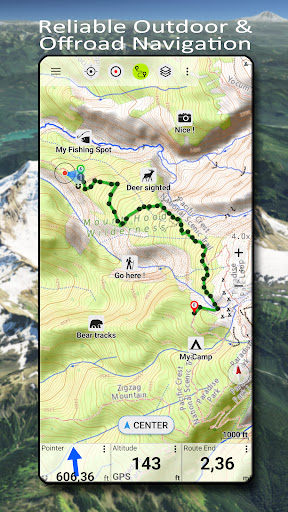
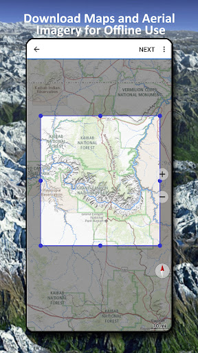
Easy to use outdoor navigation app with free access to the best available maps and aerial imagery for the USA.
Choose between 30+ map layers (topos, aerials, sea charts, ...) to plan the perfect trip and
turn your Andoid Phone/Tablet into an outdoor GPS for offline trips into the backcountry.
Add easily maps from other sources (GeoPDF, GeoTiff, Online Map Services like WMS, ...)
Available basemap layers for USA:
• USGS National Map Topo
• USGS National Map Imagery Topo
• USGS National Map Imagery
• USGS NAIP HiRes Imagery
• USGS Topo traditional DRGs: Seamless coverage of topo maps of the USA at Scales 1:250.000, 1:100.000, 1:63.000 and 1:24.000/25.000
• FSTopo Forest Maps
• NOAA Nautical RNC Charts
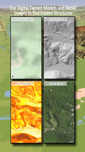
• National Elevation Maps (Hillshade, Slope Map, Aspect Map)
Worldwide basemap layers:
• OpenStreetMaps (5 different map layouts), also downloadable in space saving vectorformat
• Google Maps (Satellite images, Road- and Terrain-Map)
• Bing Maps (Satellite images, Road-Map)
• Earth At Night
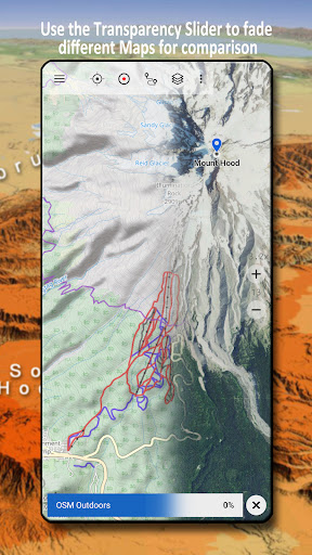
Configure a basemap layer as an overlay and utilize a transparency fader to seamlessly compare maps with each other.
Add maps from other sources:
• Import raster maps in GeoPDF, GeoTiff, MBTiles or Ozi (Oziexplorer OZF2 & OZF3)
• Add web mapping services as WMS or WMTS/Tileserver
• Import OpenStreetMaps in Vectorformat, eg complete USA for just some GBs
Available US map Overlays - add additional information to any other base map:
• Public Land Ownership (PAD-US 3)
• National Hydrographic Dataset
• Motor Vehicle Use Map (USDA)
• Elevation Contourlines
• 4WD Trails
• Trails
• Roads, Railroads, Airports
Available worldwide overlays:
• Hillshading overlay
• 20m Contourlines
• OpenSeaMap
There is no perfect map. Toggle between the different map layers or use the compare maps feature to find the most interesting route. Especially the old traditional DRGs contain many small pathes or other features that are missing on modern maps.
Main features for outdoor-navigation:
• Download map data for OFFLINE USAGE
• Measure pathes and aereas
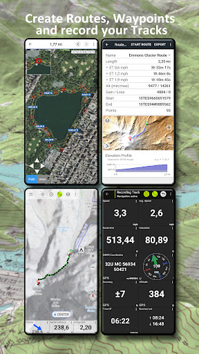
• Create and edit Waypoints
• GoTo-Waypoint-Navigation
• Create and edit Routes
• Route-Navigation (Point-to-Point Navigation)
• Track Recording (with speed, elevation and accuracy profile)
• Tripmaster with fields for odometer, average speed, bearing, elevation, etc.
• GPX/KML/KMZ Import/Export
• Search (placenames, POIs, streets)
• Get elevation and distance
• Customizable datafields in Map View and Tripmaster (e.g. Speed, Distance, Compass, ...)
• Share Waypoints, Tracks or Routes (via eMail, Dropbox, WhatsApp, ..)
• Use coordinates in WGS84, UTM or MGRS/USNG (Military Grid/ US National Grid),
• Track Replay
• and many more ...
Use this navigation app for outdoor activities like hiking, biking, camping, climbing, riding, skiing, canoeing, hunting, snowmobile tours, offroad 4WD tours or search&rescue (SAR).
Add custom waypoints in longitude/latitude, UTM or MGRS/USNG format with WGS84 datum.
Import/Export/Share GPS-Waypoints/Tracks/Routes in GPX or Google Earth KML/KMZ format.
See animated NEXRAD rain radar to make accurate predictions when raining will start/stop
Please send questions, comments and feature requests to [email protected]
Choose between 30+ map layers (topos, aerials, sea charts, ...) to plan the perfect trip and
turn your Andoid Phone/Tablet into an outdoor GPS for offline trips into the backcountry.
Add easily maps from other sources (GeoPDF, GeoTiff, Online Map Services like WMS, ...)
Available basemap layers for USA:
• USGS National Map Topo
• USGS National Map Imagery Topo
• USGS National Map Imagery
• USGS NAIP HiRes Imagery
• USGS Topo traditional DRGs: Seamless coverage of topo maps of the USA at Scales 1:250.000, 1:100.000, 1:63.000 and 1:24.000/25.000
• FSTopo Forest Maps
• NOAA Nautical RNC Charts
• National Elevation Maps (Hillshade, Slope Map, Aspect Map)
Worldwide basemap layers:
• OpenStreetMaps (5 different map layouts), also downloadable in space saving vectorformat
• Google Maps (Satellite images, Road- and Terrain-Map)
• Bing Maps (Satellite images, Road-Map)
• Earth At Night
Configure a basemap layer as an overlay and utilize a transparency fader to seamlessly compare maps with each other.
Add maps from other sources:
• Import raster maps in GeoPDF, GeoTiff, MBTiles or Ozi (Oziexplorer OZF2 & OZF3)
• Add web mapping services as WMS or WMTS/Tileserver
• Import OpenStreetMaps in Vectorformat, eg complete USA for just some GBs
Available US map Overlays - add additional information to any other base map:
• Public Land Ownership (PAD-US 3)
• National Hydrographic Dataset
• Motor Vehicle Use Map (USDA)
• Elevation Contourlines
• 4WD Trails
• Trails
• Roads, Railroads, Airports
Available worldwide overlays:
• Hillshading overlay
• 20m Contourlines
• OpenSeaMap
There is no perfect map. Toggle between the different map layers or use the compare maps feature to find the most interesting route. Especially the old traditional DRGs contain many small pathes or other features that are missing on modern maps.
Main features for outdoor-navigation:
• Download map data for OFFLINE USAGE
• Measure pathes and aereas
• Create and edit Waypoints
• GoTo-Waypoint-Navigation
• Create and edit Routes
• Route-Navigation (Point-to-Point Navigation)
• Track Recording (with speed, elevation and accuracy profile)
• Tripmaster with fields for odometer, average speed, bearing, elevation, etc.
• GPX/KML/KMZ Import/Export
• Search (placenames, POIs, streets)
• Get elevation and distance
• Customizable datafields in Map View and Tripmaster (e.g. Speed, Distance, Compass, ...)
• Share Waypoints, Tracks or Routes (via eMail, Dropbox, WhatsApp, ..)
• Use coordinates in WGS84, UTM or MGRS/USNG (Military Grid/ US National Grid),
• Track Replay
• and many more ...
Use this navigation app for outdoor activities like hiking, biking, camping, climbing, riding, skiing, canoeing, hunting, snowmobile tours, offroad 4WD tours or search&rescue (SAR).
Add custom waypoints in longitude/latitude, UTM or MGRS/USNG format with WGS84 datum.
Import/Export/Share GPS-Waypoints/Tracks/Routes in GPX or Google Earth KML/KMZ format.
See animated NEXRAD rain radar to make accurate predictions when raining will start/stop
Please send questions, comments and feature requests to [email protected]
What's New
・Fixes
App Information
Version Name
7.2.3
Version Code
340
File Size
65.5 MB
Minimum OS
Android 7.0+
Target SDK
Android 34
Developer
ATLOGIS Geoinformatics GmbH & Co. KG
Contact
Website
Content Rating
Everyone
Package Name
com.atlogis.northamerica.freePermissions Required
This app may request the following permissions:
Recent Reviews

James B
4.0★
Fantastic app! The only complaint is that I wish there was a way to overlay multiple maps at once. I would love the ability to set the base map as satellite imagery, then overlay both aspect and contour maps! Unfortunately, it seems only one other map can be overlaid at a time. Other than that, love it!

James R. Jennings
5.0★
This app puts an entire map cabinet in your pocket! Gone are the days of an entire back seat filled with maps and still missing the needed one. It's also a lot easier to determine your map location using the GPS, than by searching for identifying land features. Unfortunately, the concentration on routes often interferes with simply displaying the map and my location. I have not yet wanted to save a route, but an easy way to save a point would be nice.

Hayden Boggs
4.0★
I recently used this app as a fall back for a land navigation exercise I was running. There were a lot of pros and cons I witnessed in two days of heavy use, but the experience was positive over all. The map was more accurate that I expected, and the GPS was accurate when it was working. My problems with the app are GPS reliability and way points dissappearing for no reason (fixed by going to legend, clicking on the way point, and pushing "show on map"). Needs some work, but a very useful tool.

Herb Schroeder
5.0★
I'm upgrading this to 5 stars. I finally found an Android setting under the app's battery usage that needs to be set to Unlimited. With that change, the tracking function works as it should. [Original post: Would be 5 stars if I could get the tracking function to work without having to keep the display on at all times. Turning off the display stops recording the track, which makes it unusable for anything longer than a very short walk. I've given the app every permission I can find and turned off the device's battery-saving features, but have not been able to find any way to solve this issue.]

K Halladay
4.0★
This is a fantastically useful app. It's generally easy to use, reliable, and provides a wide selection of base layers and overlays. Route tracking is accurate, and even while active, isn't too bad a drain on battery life. I still carry a backup paper map in more remote areas, but I'm very comfortable using this app as a primary. Really I'd like to give this app 4.5, not 4 stars, the half-star for the confusing process of importing data from external sources. That said, it's worth every penny.

Shane Shepherd
1.0★
Overall, not bad. But, if you want to download a detailed area of your state for when you have no cell signal - good luck! I've been trying to download a segment of my state for five days! First, there is no "resume" if the download stops. There is "restart" and the app tries to download everything again. It validates some tiles - but, the validation takes so long that my phone will pause so to inactivity before it finishes validating! I can never get more than 75% of level 16.
Ad slot: In-Content