AviNavi, navigation for pilots
com.bbflight.avinavi
by Candidus
Screenshots


Ad slot: Top Leaderboard
About this app
Aviation navigation made simple and affordable. All VFR, low-altitude IFR and instrument approach charts for the continental United States, with full flight planning, including support for airway navigation. Overlays for Nexrad, METARs and AIRMETS/SIGMETS improve flight safety, and detailed airport information (runways, frequencies, fuel, weather) is at your fingertips.
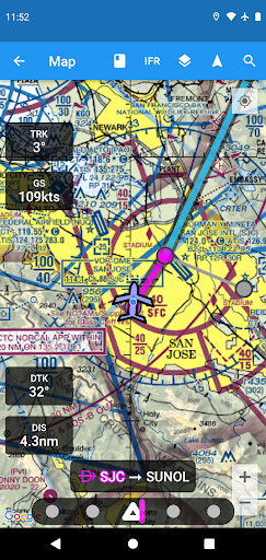
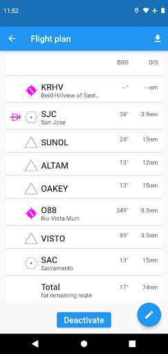
Use the moving map to search or select an airport, VOR, NDB or intersection and start direct-to navigation, or add to the flight plan. Alternatively enter the flight plan in text, e.g. KPAO SUNOL V334 SAC KSAC will load the full flight plan, including all airway navigation points.
Instrument approach charts include the airport diagram, STARS, DPs and minimums, as well as the legend.
Nearby airports are shown in green or red to indicate whether or not those airports are likely reachable in a no-wind glide.
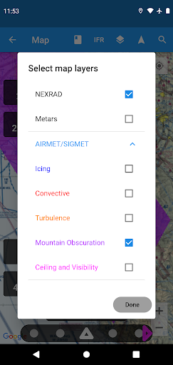
METAR, TAF, AIRMET, SIGMET, Prog charts, Convective Outlook and Wind are available as graphical and/or textual information. METARs and AIRMETS/SIGMETS can be overlayed on the map using the Layers button. Airport information shows METARs and TAFs in plain English, and Prog charts, Convective Outlook and Wind graphics for different times and altitudes are available as full screen graphics.
AviNavi requires a monthly or annual subscription, following a free trial period.
Use the moving map to search or select an airport, VOR, NDB or intersection and start direct-to navigation, or add to the flight plan. Alternatively enter the flight plan in text, e.g. KPAO SUNOL V334 SAC KSAC will load the full flight plan, including all airway navigation points.
Instrument approach charts include the airport diagram, STARS, DPs and minimums, as well as the legend.
Nearby airports are shown in green or red to indicate whether or not those airports are likely reachable in a no-wind glide.
METAR, TAF, AIRMET, SIGMET, Prog charts, Convective Outlook and Wind are available as graphical and/or textual information. METARs and AIRMETS/SIGMETS can be overlayed on the map using the Layers button. Airport information shows METARs and TAFs in plain English, and Prog charts, Convective Outlook and Wind graphics for different times and altitudes are available as full screen graphics.
AviNavi requires a monthly or annual subscription, following a free trial period.
What's New
Weather graphics now includes the GFA web tool; fixed NOTAM bug
App Information
Version Name
2.1
Version Code
20011
File Size
12.3 MB
Min SDK
Android 17+
Target SDK
Android 23
Developer
Candidus
Contact
Website
Content Rating
Everyone
Package Name
com.bbflight.avinaviPermissions Required
This app may request the following permissions:
Recent Reviews

MDK 2004
1.0★
Not signing up for a plan till i can see it work..

A Google user
1.0★
awfull
Ad slot: In-Content