Planit Pro: Photo Planner
com.yingwen.photographertoolspro
by JIDE Software
Screenshots


Ad slot: Top Leaderboard
About this app
Please email [email protected] for bug reports or feature requests. Please also remember to visit https://youtu.be/JFpSi1u0-is for more video tutorials. Each video only lasts a few minutes but you will sure learn a lot from them. You can also reach us through Instagram or Facebook. Links are under the menu inside the app.
This is a special call to landscape photographers, travel photographers, nature photographers and those who are interested in night photography, city photography, time-lapse, star-trails, milky way or astro-photography: look no more, this is the ultimate app for you - the Planit Pro. It only costs you a cup of Frappuccino but will save you tons of time and effort and a lot of gas money. Most importantly, it will make you enjoying landscape photography even more.
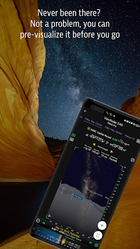
Ansel Adams dedicates the beginning of his first book "Taos Pueblo" to visualization. He introduced the idea of "previsualization", which involved the photographer imagining what he wanted his final print to look like before he even took the shot. Of course, there are many great photos which were taken impromptu. However, for landscape photographers, being able to previsualize the scene before going there will greatly reduce the chance of being caught unprepared and will greatly increase the chance of getting better shots.
Photographers use various tools to help them pre-visualizing the scene. Nowadays, many of those tools are phone apps. Planit Pro is an all-in-one solution that is designed to leverage the map and simulated viewfinder technologies to provide the necessary tools for photographers to pre-visualize the scene in combination with the ground subjects and the celestial objects such as the Sun, the Moon, Stars, Star-trails and Milky Way.
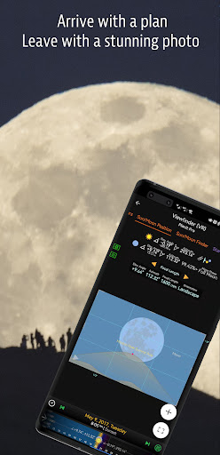
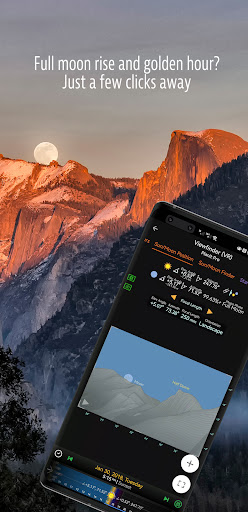
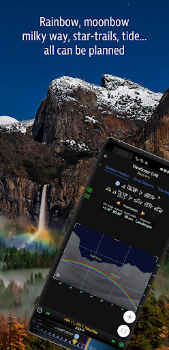
In the Planit Pro app, we packed it with features - from location scouting such as GPS coordinates, elevations, distance, elevation gain, clear view, focal length, depth of field (DoF), hyperfocal distance, panorama and aerial photography, to the Ephemeris features such as the sunrise, sunset, moonrise, moonset time and direction, twilight time, special hours of the day, sun/moon finder, major stars, constellations, nebulae azimuth and elevation angle, star trail planning, time-lapse calculation and simulation, sequence calculation and simulation, milky way searching, solar eclipse and lunar eclipse, exposure/ND filter calculator, light meter, rainbow position prediction, tide height and tide search etc. All the information are either represented on the map as an overlay or visually presented in simulated viewfinders (VR, AR, picture, or street view), just like you look through your camera's viewfinder. Whatever you want for your landscape photography, it is there in the Planit Pro.
Landscape photography is an adventure in the nature world. We understand sometimes there won't be any network connection when you are out exploring. Planit Pro was designed for have it in mind. If you preload the offline elevation files and the offline mbtiles maps, you can use the app fully offline without the need for network connections.
This is a special call to landscape photographers, travel photographers, nature photographers and those who are interested in night photography, city photography, time-lapse, star-trails, milky way or astro-photography: look no more, this is the ultimate app for you - the Planit Pro. It only costs you a cup of Frappuccino but will save you tons of time and effort and a lot of gas money. Most importantly, it will make you enjoying landscape photography even more.
Ansel Adams dedicates the beginning of his first book "Taos Pueblo" to visualization. He introduced the idea of "previsualization", which involved the photographer imagining what he wanted his final print to look like before he even took the shot. Of course, there are many great photos which were taken impromptu. However, for landscape photographers, being able to previsualize the scene before going there will greatly reduce the chance of being caught unprepared and will greatly increase the chance of getting better shots.
Photographers use various tools to help them pre-visualizing the scene. Nowadays, many of those tools are phone apps. Planit Pro is an all-in-one solution that is designed to leverage the map and simulated viewfinder technologies to provide the necessary tools for photographers to pre-visualize the scene in combination with the ground subjects and the celestial objects such as the Sun, the Moon, Stars, Star-trails and Milky Way.
In the Planit Pro app, we packed it with features - from location scouting such as GPS coordinates, elevations, distance, elevation gain, clear view, focal length, depth of field (DoF), hyperfocal distance, panorama and aerial photography, to the Ephemeris features such as the sunrise, sunset, moonrise, moonset time and direction, twilight time, special hours of the day, sun/moon finder, major stars, constellations, nebulae azimuth and elevation angle, star trail planning, time-lapse calculation and simulation, sequence calculation and simulation, milky way searching, solar eclipse and lunar eclipse, exposure/ND filter calculator, light meter, rainbow position prediction, tide height and tide search etc. All the information are either represented on the map as an overlay or visually presented in simulated viewfinders (VR, AR, picture, or street view), just like you look through your camera's viewfinder. Whatever you want for your landscape photography, it is there in the Planit Pro.
Landscape photography is an adventure in the nature world. We understand sometimes there won't be any network connection when you are out exploring. Planit Pro was designed for have it in mind. If you preload the offline elevation files and the offline mbtiles maps, you can use the app fully offline without the need for network connections.
What's New
Reset the exposure compensation to 0 when one of the five exposure parameters becomes auto.
Add a 3D model preview screen when editing 3D model (yet to be polished).
Added NAM to forecast model.
ECMWF now supports high resolution model at 8 km and 1 hour resolution.
Added a low-limit exposure settings to the Exposure Guide.
Add a 3D model preview screen when editing 3D model (yet to be polished).
Added NAM to forecast model.
ECMWF now supports high resolution model at 8 km and 1 hour resolution.
Added a low-limit exposure settings to the Exposure Guide.
App Information
Version Name
4.9
Version Code
96
File Size
38.6 MB
Minimum OS
Android 7.0+
Target SDK
Android 23
Developer
JIDE Software
Contact
Website
Content Rating
Everyone
Package Name
com.yingwen.photographertoolsproPermissions Required
This app may request the following permissions:
Recent Reviews

Mark Sblendorio
4.0★
Great app with tons of features. Takes a bit of work to understand how to use them - but there are decent tutiotials online and on YouTube. The biggest negative is the subscription model - I don't mind paying for features - but the app always...*always* has the subscription dates wrong, and always thinks you are not subscribed when you are - and restoring doesn't really help. It's a loop you can't seem to get out of.

Simone Petullà
2.0★
Potentially a good app but their subscription system is a mess. You pay it works for a while and suddenly the app decides you don't have a subscription. You want to renew but it says you already have a subscription. You check your app store and subscription is until November, try to use the feature, the app says your subscription is until July. it's an endless loop Also finicky to navigate, so many info on the screen, to pinch and zoom on the map you need baby fingers 3D works only on big cities
Jorge Romero
3.0★
it's useful but I encountered an issue after some time using it. On the main screen at the bottom the date and time selector collapsed to nothing. it's squeezed to the center and this rendered the app useless! I've tried to uninstall and clear data but nothing happened. Apart from that it's very annoying that I cannot sync automatically the plans between phone and tablet.

k brad
4.0★
strap learning curve. very accurate. just using the basic subscription. Will be getting other subscriptions in due course. online tutorials are excellent.

Josh Carroll
5.0★
The best photo planning app, it has so many features and tools! I can't imagine using anything else, this app already does way more than I need.

Fatih Oktay
5.0★
The product is a bit difficult to use. But the frustrating part is that when I try to do something, it says I haven't paid. It charges additional fees for some functions. I experienced frequent freezes on the Samsung S23FE model phone. My return application was rejected by google. However, according to Turkish Consumer Law, I have the right to return it within 14 days without giving any reason.
Ad slot: In-Content