Trailforks
com.pinkbike.trailforks
by Trailforks
Screenshots
Ad slot: Top Leaderboard
About this app
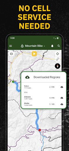
Find the ultimate bike ride planner with Trailforks. Explore the best of biking tracker and trail navigation apps with tools to help make the most of your mountain biking, gravel riding and more. Trailforks is the best backcountry navigator for your off-road adventures with the largest, professionally curated trail database. Download offline trail maps to explore anywhere. With directions to the trailhead, never getting lost on the way there.
Get the premier mountain bike activity tracker providing the most detailed top trails nearby, cycling maps, distance tracker, GPS, condition reports, trailhead navigation, and route planning tools – all in Trailforks.
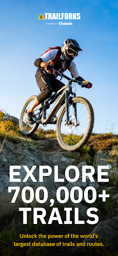
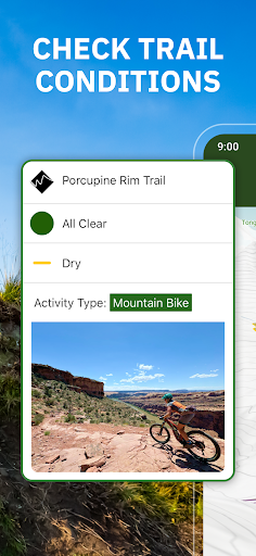
Trailforks is the largest database of trails, right in your pocket. Discover trail condition reports from trail associations and local users. Track adventures with the most powerful biking distance tracker. 700,000+ routes for your next biking adventure, cycling training, & everything in between. Our trail database is filled with up-to-date stats and info for your rides. Download today and get started.
THE BEST OF CYCLING APPS
- Biking app with the world’s largest trail database for any activity – ebiking, dirt biking and more
- GPX compatibility. Sync your Garmin or Wahoo device
- Create and share local routes
- Plan adventures with topo maps and slope markers
- Save bike trails to your Wishlist
- Bike distance tracker lets you track your mileage
- Find directions to nearby bike shops
- Get a bike tracker with route info & average time to complete
- Orientate maps in the direction you’re facing
- Track down the trailhead with driving directions
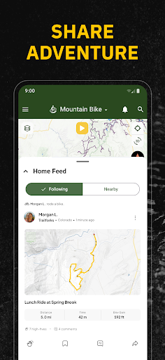
JOIN THE COMMUNITY WITH ACTIVITY FEED
- Find inspiration and trail conditions in your activity feed
- Connect devices and apps to share your stats and achievements with photos and comments
- Follow friends to discover new routes
- Explore bike reviews, destination guides, race analysis, and more from the experts at Outside, Pinkbike, and Velo.
- Access 1 million photos, videos, and 3M trail reports
MULTI-ACTIVITY SUPPORT
- Trailforks is also the ultimate backpacking and hiking app
- Find routes for hiking, trail running, and more.
- Free maps with thousands of related points of interest (POIs).
- Topo maps to help you tackle your next outdoor adventure
TRAIL EVENTS, STATUSES, WEATHER REPORTS & ALERTS
- Cycling tracker monitors trail conditions & closures
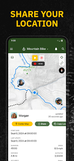
- View events nearby or by region
- Share your map location with friends & emergency services
- Check weather submit trail reports, including photos
- Earn local trail badges
- Sync and view saved 'Route Plans' from web to app
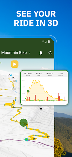
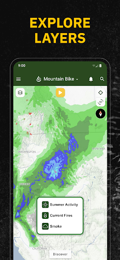
TOPOGRAPHIC MAPS FOR KEY INSIGHTS
- Bike ride with route elevation profiles displayed in-app
- Toggle Pro map layers like slope angle, light pollution, USFS, land ownership & more!
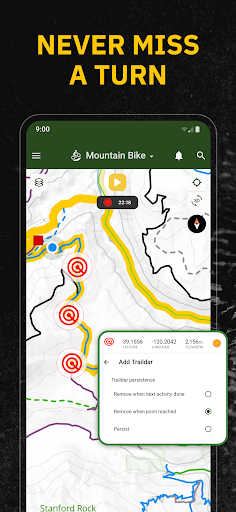
- Route creation to your preferred trailhead
- Up your outdoor game when viewing Strava segments
- Overlay of US land owners like the BLM
- View polygons for private property or closed areas
UPGRADE YOUR RIDE WITH TRAILFORKS PRO WITH OUTSIDE+
- Unlock nationwide map access, including Garmin base maps
- Priority sync with your Garmin or Strava device
- Enjoy unlimited waypoints & wishlists
- Access desktop-to-app cycling tools like printmap & downloadable GPX & KML files
- Unlimited access to the Gaia GPS offroad & hiking app
- Expert-led online courses on Outside Learn
- Premium access to award-winning films, shows, and live TV on Outside Watch
- Unlimited digital access to Outside Network's 15 iconic brands including Outside Online, Velo, and Pinkbike
Trailforks is the perfect free cycling app for your outdoor adventures. Welcome the new season with the ultimate bike tracker for your next ride – Trailforks!
Detailed trail maps for renowned mountain biking destinations such as, Whistler, Squamish, North Shore, Kamloops, Nelson, Moab, Downieville, Colorado Springs, Bellingham, Bentonville, Finale Ligure, Pisgah, Marin, Bend Oregon, Wellington & Rotorua New Zealand.
Get the premier mountain bike activity tracker providing the most detailed top trails nearby, cycling maps, distance tracker, GPS, condition reports, trailhead navigation, and route planning tools – all in Trailforks.
Trailforks is the largest database of trails, right in your pocket. Discover trail condition reports from trail associations and local users. Track adventures with the most powerful biking distance tracker. 700,000+ routes for your next biking adventure, cycling training, & everything in between. Our trail database is filled with up-to-date stats and info for your rides. Download today and get started.
THE BEST OF CYCLING APPS
- Biking app with the world’s largest trail database for any activity – ebiking, dirt biking and more
- GPX compatibility. Sync your Garmin or Wahoo device
- Create and share local routes
- Plan adventures with topo maps and slope markers
- Save bike trails to your Wishlist
- Bike distance tracker lets you track your mileage
- Find directions to nearby bike shops
- Get a bike tracker with route info & average time to complete
- Orientate maps in the direction you’re facing
- Track down the trailhead with driving directions
JOIN THE COMMUNITY WITH ACTIVITY FEED
- Find inspiration and trail conditions in your activity feed
- Connect devices and apps to share your stats and achievements with photos and comments
- Follow friends to discover new routes
- Explore bike reviews, destination guides, race analysis, and more from the experts at Outside, Pinkbike, and Velo.
- Access 1 million photos, videos, and 3M trail reports
MULTI-ACTIVITY SUPPORT
- Trailforks is also the ultimate backpacking and hiking app
- Find routes for hiking, trail running, and more.
- Free maps with thousands of related points of interest (POIs).
- Topo maps to help you tackle your next outdoor adventure
TRAIL EVENTS, STATUSES, WEATHER REPORTS & ALERTS
- Cycling tracker monitors trail conditions & closures
- View events nearby or by region
- Share your map location with friends & emergency services
- Check weather submit trail reports, including photos
- Earn local trail badges
- Sync and view saved 'Route Plans' from web to app
TOPOGRAPHIC MAPS FOR KEY INSIGHTS
- Bike ride with route elevation profiles displayed in-app
- Toggle Pro map layers like slope angle, light pollution, USFS, land ownership & more!
- Route creation to your preferred trailhead
- Up your outdoor game when viewing Strava segments
- Overlay of US land owners like the BLM
- View polygons for private property or closed areas
UPGRADE YOUR RIDE WITH TRAILFORKS PRO WITH OUTSIDE+
- Unlock nationwide map access, including Garmin base maps
- Priority sync with your Garmin or Strava device
- Enjoy unlimited waypoints & wishlists
- Access desktop-to-app cycling tools like printmap & downloadable GPX & KML files
- Unlimited access to the Gaia GPS offroad & hiking app
- Expert-led online courses on Outside Learn
- Premium access to award-winning films, shows, and live TV on Outside Watch
- Unlimited digital access to Outside Network's 15 iconic brands including Outside Online, Velo, and Pinkbike
Trailforks is the perfect free cycling app for your outdoor adventures. Welcome the new season with the ultimate bike tracker for your next ride – Trailforks!
Detailed trail maps for renowned mountain biking destinations such as, Whistler, Squamish, North Shore, Kamloops, Nelson, Moab, Downieville, Colorado Springs, Bellingham, Bentonville, Finale Ligure, Pisgah, Marin, Bend Oregon, Wellington & Rotorua New Zealand.
What's New
As often, we bring many small fixes to the app to improve your experience!
App Information
Version Name
2024.4.1
Version Code
19168330
File Size
62.8 MB
Minimum OS
Android 8.1+
Target SDK
Android 34
Developer
Trailforks
Contact
Website
Content Rating
Teen
Package Name
com.pinkbike.trailforksPermissions Required
This app may request the following permissions:
Recent Reviews

Timothy Erwig
1.0★
I'm very disappointed in what this app has become. I've been using it since it was completely free. It has recently become useless. I can't get trails to render on the map. It will not download data which is one of the reasons I pay the subscription. My confidence with this app in new unfamiliar trails is gone. I can't count on Trailforks to get me in or out of trail systems safely.

Matthew Tarquino
1.0★
I'm stuck in a loop and the app is useless for the only thing I want to do with it. Logged in to my Trailforks account, pulled up a saved route. Tried to share it to Garmin Connect. It prompts me to log in to Trailforks. Which I'm already logged into, or I wouldn't have been able to locate and open the saved route I'm currently looking at. So I log in, repeat the process, it asks me to log in again...

Cori Bucherl
1.0★
This app used to be so great. But I'm having the same issue as Timothy C from 4/17/25 now: downloaded regions aren't showing up offline, or are intermittently disappearing from my downloads folder. That, and selecting trails to review stats only works occasionally and I have yo restart the app to select more than one. Even that doesn't always work. I'm on the most recent version of the app. Honestly we don't need Strava-like recording and all that, just show me trails and where I am on them.

Wade McCaulley
1.0★
This used to be the best app but is now essentially useless. Downloaded regions no longer show up when not connected to wifi or data. it is somehow a very data hungry app that can download a few g in a few days. and still not be able to show maps. Oftentimes you can see trails when zoomed out. but they disappear as soon as you zoom in. you can pick a route from your home when connected to wifi but it will disappear by the ti.e you get to the trail head. The support has not been helpful.

Phillip
1.0★
This used to be the best mtb app, but I hate using it now. I don't even mind paying (although the yearly pricing is getting ridiculous) but over the years the user experience has gotten way worse. There were a couple summers I couldn't even log in because of the outdoor magazine account merging situation.. There are annoying pop-ups for features I don't want to use and the interface is clunky and cluttered. Over the years has been unreliable at times too.

John S
1.0★
Not user friendly at all. Very difficult to use. All I am trying to do is search trail with name but it won't. Maybe I am doing something wrong but if that's the case, it says it all. Shouldn't be this difficult to find the trail I am look for using search. Seems like I wasted my money. Alltrail is so much easier to use. Only pro a about this app is it colors the difficulty of the trails
Ad slot: In-Content