BackCountry Navigator GPS PRO icon

Phone

BackCountry Navigator GPS PRO

Maps & Navigation Nii Game INC ⭐ 3.60 100,000+
Version 8.0.5 12.9 MB Everyone

Screenshots

BackCountry Navigator GPS PRO screenshot
Permissions Explained 10 permissions requested View details

This app requests 10 permissions. The table below explains what each permission may allow and what users should review before installing.

Status Permission What it means Why it may be used User safety note
⚠️ Sensitive Modify external storage android.permission.WRITE_EXTERNAL_STORAGE 
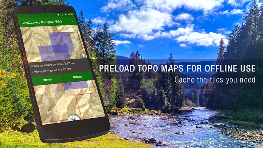
Allows the app to write or modify files in shared device storage. Used for saving downloads, media files, exports, edited documents, backups, or cached content. Sensitive permission. Make sure file access matches the app’s purpose.
⚠️ Sensitive Read phone state android.permission.READ_PHONE_STATE Allows the app to access phone status and device-related information. Used for call handling, carrier services, device identification, account security, or playback interruption handling. Sensitive permission. Review whether the app has a clear phone-related reason.
Common Internet access android.permission.INTERNET Allows the app to open network connections and communicate with online services. Commonly used for streaming, syncing, login, ads, analytics, downloads, cloud features, and app updates. Common permission. Review the app’s behavior if it does not appear to need online access.
ℹ️ Review Access Wifi State android.permission.ACCESS_WIFI_STATE This is an Android permission or app-specific permission requested by the app. The app may use this permission for features related to its category, device support, background behavior, storage, connectivity, or system integration. Review this permission before installing, especially if it does not match the app’s expected purpose.
Common View network status android.permission.ACCESS_NETWORK_STATE Allows the app to check whether the device is connected to Wi-Fi, mobile data, or another network. Often used to avoid loading content when offline or to adjust loading based on connection quality. Generally low risk by itself.
ℹ️ Review Keep device awake android.permission.WAKE_LOCK Allows the app to prevent the device from sleeping while a task is running. Used for media playback, downloads, navigation, alarms, calls, or long-running background tasks. Review battery usage if the app keeps the device awake too often.
ℹ️ Review System Alert Window android.permission.SYSTEM_ALERT_WINDOW This is an Android permission or app-specific permission requested by the app. The app may use this permission for features related to its category, device support, background behavior, storage, connectivity, or system integration. Review this permission before installing, especially if it does not match the app’s expected purpose.
⚠️ Sensitive Read external storage android.permission.READ_EXTERNAL_STORAGE Allows the app to read files from shared device storage. Used by media players, file managers, backup apps, editors, upload tools, and document apps. Sensitive permission. Review carefully if the app does not need access to files or media.
⚠️ Sensitive 
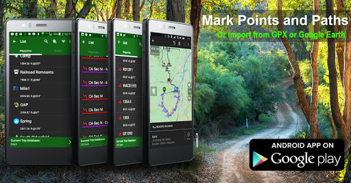
Approximate location android.permission.ACCESS_COARSE_LOCATION Allows the app to access an approximate device location. Used for weather, local content, regional features, nearby services, or location-based settings. Sensitive permission. Review whether the app needs location access.
⚠️ Sensitive Precise location android.permission.ACCESS_FINE_LOCATION Allows the app to access the device’s precise location when granted by the user. Used for maps, navigation, local recommendations, weather, rideshare, nearby devices, or location-based content. Sensitive permission. Grant only when location access matches the app’s purpose.

About BackCountry Navigator GPS PRO

Download topo maps for an offline outdoor navigator! Use your phone or tablet as an offroad topo mapping handheld GPS with the bestselling outdoor navigation app for Android! Explore beyond cell coverage for hiking and other recreation. Download topo maps for the US and many other countries in advance, so you won't need cell coverage for navigation. Use storage memory for maps. New: Android Wear support to see navigation at a glance on wrist Use GPS waypoints from GPX or KML files, or enter your own coordinates using longitude/latitude, UTM, MGRS, or grid reference. Using GOTO makes a waypoint a locus for navigation. This uses many publicly available map sources as free downloads. Some additional content available as an in app purchase: -Accuterra Topo Map Source for $19.99/year. This can be purchased and used with or in instead of the free sources. -Thunderforest Map Sources - worldwide for $11.99 per year. - Boundary maps for 12 western states from the Bureau of Land Management(BLM) Overlay for topo maps valued by hunters. -GMU boundaries in some states -Lake Contours in several states. -Content from US TrailMaps including: -ATV, Whitewater, and Equestrian Trail Maps See the menu under More-> "Purchasing AddOns". They can be shown on top of topo maps. You may try the DEMO version to make sure you like the maps in your country. About topo (topographic) maps: Topo maps show terrain through color and contours, and are useful for navigation offroad. Topo maps and GPS can be used for hiking, hunting, kayaking, snowshoeing, & backpacker trails. You can create your own maps with Mobile Atlas Creator, or specify a custom tile server. Built in sources include: OpenStreetMaps from MapQuest OpenCycleMaps showing terrain worldwide US Topo Maps from Caltopo and the USGS USTopo: Aerial Photography with markup. Canada Topo Maps from Toporama Marine maps: NOAA RNC Nautical Charts (coastal) USGS Color Aerial photography Topographic Maps of Spain and Italy Topo maps of New Zealand Japan GSI maps. Many of the above sources are generally free to use. Use offline topo maps and GPS on hiking trails without cell service. The GPS in your Android phone can get its position from GPS satellites, and you don’t have to rely on your data plan to get maps. Have more fun and safe GPS navigation in the backcountry. Use as a geocaching navigator by getting a pocket query as GPX. Besides geocaching, use GPS for recording tracks and GPS waypoints on your trip, all the while tracking your GPS quest on topographic maps. It may replace your Garmin handheld GPS. Here are some of the outdoor GPS activities BackCountry Navigator has been used for: As a hiking GPS both on hiking trails and off trail. Camping trips to find that perfect camping site or the way back to camp with GPS. Hunting trips for hunting wild game in rugged areas. Doing recon for a hunt or as your hunting GPS Fishing: make it your fishing GPS. Search and Rescue (SAR). Trekking the Pacific Crest trail or other long…

What BackCountry Navigator GPS PRO Is Used For

BackCountry Navigator GPS PRO appears to be a navigation app focused on outdoor and off-road use. Based on the metadata, it is commonly used for hiking, backpacking, hunting, kayaking, snowshoeing, and other recreation where topographic maps and GPS positioning are helpful. The app’s emphasis on downloading maps in advance suggests it may be useful when users expect to travel beyond reliable cell coverage and still need route awareness and waypoint guidance.

The app also appears to support GPX and KML waypoint files, along with manual coordinate entry in formats such as latitude/longitude, UTM, MGRS, and grid references. That makes it relevant for users who already plan routes or share locations in map-based formats. Permission requests for storage and location fit this use case, since offline maps need local storage and live navigation depends on GPS access. The presence of internet and network permissions suggests map downloads and optional online sources may be part of normal use. It may also be used on a phone or tablet, and the metadata mentions Android Wear support for quick glances at navigation information.

Common uses

  • Download and store topo maps for offline navigation
  • Use GPS position to orient yourself on trails and in remote areas
  • Open or import waypoint files such as GPX and KML
  • Enter coordinates manually for locating specific points
  • Plan outdoor trips where cell service may be limited
  • View map overlays and boundary data for recreation planning
  • Use on phone, tablet, or paired wear device for quick checks
Best for:
Hikers Backpackers Off-road travelers Outdoors users Offline navigation

App Details

Package:
com.crittermap.backcountrynavigator.license
Developer:
Nii Game INC
Version:
8.0.5
Updated:
Sep 7, 2025
Min Android:
5.0
Age Rating:
Everyone
Contains Ads:
Yes
In-App Purchases:
Yes

Official Listing

  • Official listing available on Google Play
  • Package name: com.crittermap.backcountrynavigator.license
  • Age rating: Everyone

Explore More

Browse more apps in Maps & Navigation or explore the Phone hub .

Related Maps & Navigation Apps

GPS, Maps, Driving Directions icon

GPS, Maps, Driving Directions

Maps & Navigation AppVerge Technologies, LLC

Navigate seamlessly with Real-Time Traffic, Offline Maps, and Voice Navigation.

Version 13.89 208.7 MB ⭐ 4.00 100,000,000+ installs
Sygic GPS Navigation & Maps icon

Sygic GPS Navigation & Maps

Maps & Navigation Sygic.

Sygic GPS Navigation with 3D offline maps is compatible with Android Auto.

Version Varies with device 103.6 MB ⭐ 4.20 50,000,000+ installs
Radarbot: Radar Detector, GPS icon

Radarbot: Radar Detector, GPS

Maps & Navigation Radarbot Company

Speedcam alerts and navigation. 100% Legal and Reliable. Never pay another fine!

Version Varies with device 61.4 MB ⭐ 4.10 50,000,000+ installs
GPS+ Maps, Navigation, Traffic icon

GPS+ Maps, Navigation, Traffic

Maps & Navigation JVSTUDIOS

GPS+ ensures you're always on track, live traffic info and offline maps included

Version 4.0.48 118.7 MB ⭐ 4.60 10,000,000+ installs

How to Download BackCountry Navigator GPS PRO

If this app is not hosted directly on APKApps official link, then for the safest and most up-to-date version, install it from its official Google Play listing.