About MilGPS PRO
🎯 MilGPS PRO — Profesyonel Askeri GPS Navigasyon MilGPS PRO, saha koşullarında ihtiyaç duyduğunuz her şeyi tek bir uygulamada sunan profesyonel düzeyde askeri GPS navigasyon uygulamasıdır. Arazi, operasyon ve navigasyon ihtiyaçlarınız için tasarlanmıştır. ━━━━━━━━━━━━━━━━━━━━━━━━━━━━━━━━ 📍 KONUM & KOORDİNAT SİSTEMLERİ ━━━━━━━━━━━━━━━━━━━━━━━━━━━━━━━━ - MGRS (Military Grid Reference System) — tam 10 haneli hassasiyet - UTM koordinat sistemi - USNG (US National Grid) - QTH Locator - Ondalık ve DMS LAT/LON formatları - Tek dokunuşla format değiştirme - Anlık koordinat kopyalama ━━━━━━━━━━━━━━━━━━━━━━━ 🗺️ GELİŞMİŞ HARİTA SİSTEMİ ━━━━━━━━━━━━━━━━━━━━━━━ - 6 farklı harita katmanı: Uydu, Topografik, Yol, Hibrit, Arazi, Bing Uydu - Askeri grid çizgisi overlay'i - Gölge rölyef, izohips ve yol isimleri overlay katmanları - Katman şeffaflık kontrolü - Koordinata göre harita arama (MGRS, LAT/LON, DMS) - Çevrimdışı harita indirme ve önbellekleme - 3B arazi görünümü ━━━━━━━━━━━━━━━━━━━━━ 🎯 HEDEF YÖNETİMİ ━━━━━━━━━━━━━━━━━━━━━ - Sınırsız hedef (waypoint) kaydetme - Haritaya uzun basarak anında hedef ekleme - Manuel MGRS koordinat girişi - GPX, KML, KMZ, CSV ve MGRS listesi içe aktarma - Hedef taşıma, yeniden adlandırma, silme - Tüm hedefleri GPX olarak dışa aktarma - Deep link ile hedef paylaşma - Hedefe mesafe ve yön bilgisi ━━━━━━━━━━━━━━━━━━━━━━━ 🧭 PUSULA & NAVİGASYON ━━━━━━━━━━━━━━━━━━━━━━━ - Gerçek zamanlı dijital askeri pusula - Mutlak ve relatif yön gösterimi - Hedefe yön okuyucu - Rota sapma uyarısı - ETA (tahmini varış süresi) hesaplama - Radar tarama efektli pusula ekranı ━━━━━━━━━━━━━━━━━━━━━━ 🚶 ROTA & İNTİKAL MODU ━━━━━━━━━━━━━━━━━━━━━━ - Harita üzerinde rota çizimi - Çok noktali güzergah planlama - Rota kaydetme ve yükleme - GPX rota içe/dışa aktarma - İntikal modu: aktif navigasyon ve rota takibi - Rotadan sapma göstergesi - Toplam mesafe hesaplama ━━━━━━━━━━━━━━━━━━━━━ 📡 İZ TAKİBİ (TRACK) ━━━━━━━━━━━━━━━━━━━━━ - Otomatik iz kaydı - Durdurma ve duraklatma - Anlık hız, maksimum hız, ortalama hız - Toplam tırmanış ve iniş hesaplama - Maksimum/minimum rakım takibi - Kaydedilen izleri haritada görüntüleme - GPX olarak dışa aktarma ━━━━━━━━━━━━━━━━━━━━━━━━━━━ 📊 SENSÖR & GERÇEK ZAMANLI VERİ ━━━━━━━━━━━━━━━━━━━━━━━━━━━━━ - GPS doğruluk göstergesi - Rakım ve arazi tipi (Düzlük / Tepe / Dağlık / Yüksek Dağ) - Barometre ve atmosfer basıncı - Anlık hız (km/s ve mph) - Yerel saat ve Zulu (UTC) DTG gösterimi - Metrik / İmperial birim değiştirici ━━━━━━━━━━━━━━━━━━━━━━━ 🛠️ ARAÇLAR ━━━━━━━━━━━━━━━━━━━━━━━ - Koordinat dönüştürücü (LAT/LON → MGRS/UTM) - Alan hesaplama (m² / km² / acres) - Mesafe ölçer - Çevrimdışı harita indirici (Bölgesel / İlçe / Mahalle zoom seviyeleri) ━━━━━━━━━━━━━━━━━━━━━━━━━ 🔒 GÜVENİLİRLİK & PERFORMANS ━━━━━━━━━━━━━━━━━━━━━━━━━ - İnternet bağlantısı olmadan tam çalışma - Önbelleğe alınmış haritalarla çevrimdışı kullanım - Arka planda konum takibi - Düşük pil tüketimi için optimize edilmiş - Tüm veriler cihazda saklanır, gizlilik öncelikli…
What MilGPS PRO Is Used For
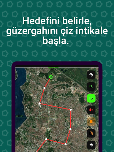
MilGPS PRO appears to be a phone-based maps and navigation app built for field navigation, route planning, and coordinate handling. Based on the metadata, it is centered on military-style GPS workflows rather than casual turn-by-turn driving directions. Users may rely on it to view maps, enter or convert coordinates, mark waypoints, and keep track of movement in terrain or operation settings.
The app’s listed permissions fit that use case: approximate and precise location access support live positioning, while network access may be used for map content, downloads, or license checks. The description also points to offline map caching, route tracking, and track recording, which suggests it may be useful when moving through areas with limited connectivity. It appears designed for detailed navigation tasks where coordinate formats such as MGRS, UTM, LAT/LON, and DMS matter.
Common uses may include saving target points, following planned routes, viewing elevation and terrain layers, and exporting or importing GPX, KML, KMZ, or CSV data. Because it is described as a professional military GPS tool, it may be most relevant to users who already understand map coordinates and navigation terminology.
Common uses
- View maps with terrain, satellite, road, and hybrid layers
- Convert and copy coordinates in formats like MGRS, UTM, and LAT/LON
- Save waypoints and import/export route or track files
- Record movement tracks and review speed, elevation, and distance data
- Plan multi-point routes and follow them in navigation mode
- Use offline map caching when network access is limited
App Details
Package:
com.milgpspro.jsps
Developer:
Military App
Version:
Varies with device
Min Android:
Varies with device
Age Rating:
Everyone
Contains Ads:
No
In-App Purchases:
No
Official Listing
-
Official listing available on
Google Play
-
Package name:
com.milgpspro.jsps
-
Age rating:
Everyone
Related Maps & Navigation Apps
Maps & Navigation
•
Moovit
Version Varies with device
57.5 MB
⭐ 3.80
100,000,000+ installs
Maps & Navigation
•
AppVerge Technologies, LLC
Navigate seamlessly with Real-Time Traffic, Offline Maps, and Voice Navigation.
Version 13.89
208.7 MB
⭐ 4.00
100,000,000+ installs
Maps & Navigation
•
Sygic.
Sygic GPS Navigation with 3D offline maps is compatible with Android Auto.
Version Varies with device
103.6 MB
⭐ 4.20
50,000,000+ installs
Maps & Navigation
•
Family Locator Inc.
Version 6.91
9.2 MB
⭐ 4.30
50,000,000+ installs
Maps & Navigation
•
Radarbot Company
Speedcam alerts and navigation. 100% Legal and Reliable. Never pay another fine!
Version Varies with device
61.4 MB
⭐ 4.10
50,000,000+ installs
Maps & Navigation
•
JVSTUDIOS
GPS+ ensures you're always on track, live traffic info and offline maps included
Version 4.0.48
118.7 MB
⭐ 4.60
10,000,000+ installs
How to Download MilGPS PRO
If this app is not hosted directly on APKApps official link,
then for the safest and most up-to-date version, install it from its official Google Play listing.