|
ℹ️
Review
|
Reorder Tasks
android.permission.REORDER_TASKS
|
This is an Android permission or app-specific permission requested by the app. |
The app may use this permission for features related to its category, device support, background behavior, storage, connectivity, or system integration. |
Review this permission before installing, especially if it does not match the app’s expected purpose. |
|
ℹ️
Review
|
Keep device awake
android.permission.WAKE_LOCK
|
Allows the app to prevent the device from sleeping while a task is running. |
Used for media playback, downloads, navigation, alarms, calls, or long-running background tasks. |
Review battery usage if the app keeps the device awake too often. |
|
⚠️
Sensitive
|
Camera access
android.permission.CAMERA
|
Allows the app to use the device camera. |
Used for QR scanning, taking photos, video calls, document capture, AR features, or profile images. |
Sensitive permission. Grant only when camera features are expected. |
|
ℹ️
Review
|
Change Wifi Multicast State
android.permission.CHANGE_WIFI_MULTICAST_STATE
|
This is an Android permission or app-specific permission requested by the app. |
The app may use this permission for features related to its category, device support, background behavior, storage, connectivity, or system integration. |
Review this permission before installing, especially if it does not match the app’s expected purpose. |
|
⚠️
Sensitive
|
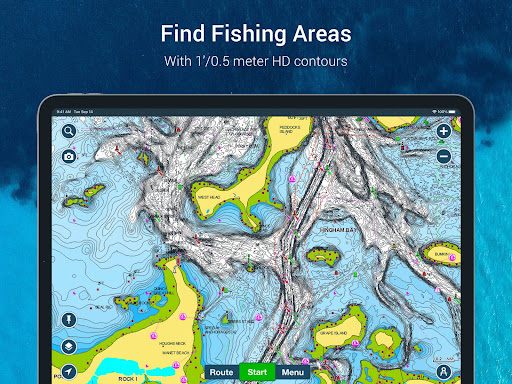
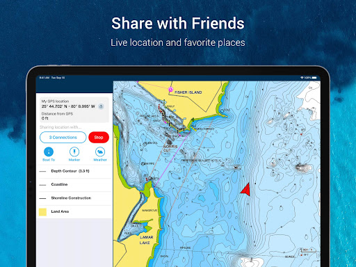
Precise location
android.permission.ACCESS_FINE_LOCATION
|
Allows the app to access the device’s precise location when granted by the user. |
Used for maps, navigation, local recommendations, weather, rideshare, nearby devices, or location-based content. |
Sensitive permission. Grant only when location access matches the app’s purpose. |
|
⚠️
Sensitive
|
Approximate location
android.permission.ACCESS_COARSE_LOCATION
|
Allows the app to access an approximate device location. |
Used for weather, local content, regional features, nearby services, or location-based settings. |
Sensitive permission. Review whether the app needs location access. |
|
ℹ️
Review
|
Access Wifi State
android.permission.ACCESS_WIFI_STATE
|
This is an Android permission or app-specific permission requested by the app. |
The app may use this permission for features related to its category, device support, background behavior, storage, connectivity, or system integration. |
Review this permission before installing, especially if it does not match the app’s expected purpose. |
|
✅
Common
|
View network status
android.permission.ACCESS_NETWORK_STATE
|
Allows the app to check whether the device is connected to Wi-Fi, mobile data, or another network. |
Often used to avoid loading content when offline or to adjust loading based on connection quality. |
Generally low risk by itself. |
|
✅
Common
|
Internet access
android.permission.INTERNET
|
Allows the app to open network connections and communicate with online services. |
Commonly used for streaming, syncing, login, ads, analytics, downloads, cloud features, and app updates. |
Common permission. Review the app’s behavior if it does not appear to need online access. |
|
✅
Common
|
Vibration control
android.permission.VIBRATE
|
Allows the app to control device vibration. |
Used for notifications, alerts, haptic feedback, timers, alarms, or game feedback. |
Generally low risk by itself. |
|
ℹ️
Review
|
Read Media Images
android.permission.READ_MEDIA_IMAGES
|
This is an Android permission or app-specific permission requested by the app. |
The app may use this permission for features related to its category, device support, background behavior, storage, connectivity, or system integration. |
Review this permission before installing, especially if it does not match the app’s expected purpose. |
|
⚠️
Sensitive
|
Modify external storage
android.permission.WRITE_EXTERNAL_STORAGE
|
Allows the app to write or modify files in shared device storage. |
Used for saving downloads, media files, exports, edited documents, backups, or cached content. |
Sensitive permission. Make sure file access matches the app’s purpose. |
|
⚠️
Sensitive
|
Read external storage
android.permission.READ_EXTERNAL_STORAGE
|
Allows the app to read files from shared device storage. |
Used by media players, file managers, backup apps, editors, upload tools, and document apps. |
Sensitive permission. Review carefully if the app does not need access to files or media. |
|
ℹ️
Review
|
Send notifications
android.permission.POST_NOTIFICATIONS
|
Allows the app to send notifications to the device. |
Used for alerts, reminders, messages, account activity, updates, or media controls. |
Review notification settings if the app sends too many alerts. |
|
ℹ️
Review
|
Vending Check License
com.android.vending.CHECK_LICENSE
|
This is an Android permission or app-specific permission requested by the app. |
The app may use this permission for features related to its category, device support, background behavior, storage, connectivity, or system integration. |
Review this permission before installing, especially if it does not match the app’s expected purpose. |
|
ℹ️
Review
|
Get Accounts
android.permission.GET_ACCOUNTS
|
This is an Android permission or app-specific permission requested by the app. |
The app may use this permission for features related to its category, device support, background behavior, storage, connectivity, or system integration. |
Review this permission before installing, especially if it does not match the app’s expected purpose. |
|
ℹ️
Review
|
Foreground Service
android.permission.FOREGROUND_SERVICE
|
This is an Android permission or app-specific permission requested by the app. |
The app may use this permission for features related to its category, device support, background behavior, storage, connectivity, or system integration. |
Review this permission before installing, especially if it does not match the app’s expected purpose. |
|
ℹ️
Review
|
Foreground Service Location
android.permission.FOREGROUND_SERVICE_LOCATION
|
This is an Android permission or app-specific permission requested by the app. |
The app may use this permission for features related to its category, device support, background behavior, storage, connectivity, or system integration. |
Review this permission before installing, especially if it does not match the app’s expected purpose. |
|
ℹ️
Review
|
C2dm Permission Receive
com.google.android.c2dm.permission.RECEIVE
|
This is an Android permission or app-specific permission requested by the app. |
The app may use this permission for features related to its category, device support, background behavior, storage, connectivity, or system integration. |
Review this permission before installing, especially if it does not match the app’s expected purpose. |
|
ℹ️
Review
|
Gms Permission Ad Id
com.google.android.gms.permission.AD_ID
|
This is an Android permission or app-specific permission requested by the app. |
The app may use this permission for features related to its category, device support, background behavior, storage, connectivity, or system integration. |
Review this permission before installing, especially if it does not match the app’s expected purpose. |
|
ℹ️
Review
|
Receive Boot Completed
android.permission.RECEIVE_BOOT_COMPLETED
|
This is an Android permission or app-specific permission requested by the app. |
The app may use this permission for features related to its category, device support, background behavior, storage, connectivity, or system integration. |
Review this permission before installing, especially if it does not match the app’s expected purpose. |
|
ℹ️
Review
|
Finsky Permission Bind Get Install Referrer Service
com.google.android.finsky.permission.BIND_GET_INSTALL_REFERRER_SERVICE
|
This is an Android permission or app-specific permission requested by the app. |
The app may use this permission for features related to its category, device support, background behavior, storage, connectivity, or system integration. |
Review this permission before installing, especially if it does not match the app’s expected purpose. |
|
ℹ️
Review
|
Vending Billing
com.android.vending.BILLING
|
This is an Android permission or app-specific permission requested by the app. |
The app may use this permission for features related to its category, device support, background behavior, storage, connectivity, or system integration. |
Review this permission before installing, especially if it does not match the app’s expected purpose. |
|
ℹ️
Review
|
It Navionics Singleappmarinelakeshd Dynamic Receiver Not Exported Permission
it.navionics.singleAppMarineLakesHD.DYNAMIC_RECEIVER_NOT_EXPORTED_PERMISSION
|
This is an Android permission or app-specific permission requested by the app. |
The app may use this permission for features related to its category, device support, background behavior, storage, connectivity, or system integration. |
Review this permission before installing, especially if it does not match the app’s expected purpose. |